Tuesday, July 28, 2009

Katahdin Summit - Completion of Trail

5.2 miles, 2178.3 total.
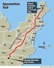
It has been COMPLETED!!  At 9:25 AM eastern time I reached the summit of Katahdin and the northern terminus of the Appalachian Trail in Maine.  Five months and two days after I began my journey on February 26th in Georgia.
Didn't sleep much at all last night and decided to hit the trail before the Amigos, because I knew they would catch up with me at some point. I left camp at 6:30 and the climb was amazing and really tough. Probably the toughest of the entire trail, with an elevation gain of 4400 feet.  On the way up I was in a mist and clouds until the very top, so I didn't have any views and wasn't able to see anything except the trail at my feet.  The first mile or so was normal trail and then I put away my hiking poles and I just climbed rocks - hand over hand most of the way.  With 2.5 miles remaining it becomes a complete rock climb straight up giant boulders over the spine of the mountain.  Then with about 1.25 miles remaining, after the Amigos caught up with me, we hit the "table land", a flat area (slight ascent) above tree line that is covered with rocks.  With about a half mile remaining it starts to go up again over larger rocks.  there are several false summits - places you think you've reached the top but the trail keeps going up - until finally you see the official summit sign. holy cow.
As we reached the summit the mist and clouds began to clear and we had absolutely amazing views.  the bad part is that we had to go right back down the way we came up.  oh well.  What an amazing hike.
One of the coolest things to happen to me on the trail took place this morning.  On the way up and on the way back down I passed a family that I had met in Harpers Ferry, WV.  They recognized me and cheered me on as I went up and then congratulated me on the way down.
An absolutely amazing journey.  Right now I want to relax and rest; my feet hurt.
When i get back to NYC on August 1 or 2 I will post a follow up message with the best summit picture, and then in about a week I will post a link to many of the pictures I took - after I go through all of them.

a few stats-
total miles: 2178.3 (not including side trails and walking to and in towns)
number of days hiked in shorts: 3 (i don't like hiking in shorts!)
number of days hiked in short sleeves: 4 (i don't like hiking in short sleeves!)
number of pictures taken: 2000+ (i like to take pics)
pairs of shoes: 5 (ugh)
bear sightings: 8 (grrrrrrr....)
moose sightings: 2 (ohhhoooooo)
weight lost: 50 lbs. + (did i have that much to lose?)
number of shaves and hair cuts: 3 (i'm a beast!)
approximate % of days with rain: 65 (ugh!!)

Thank you all for your support.  You will hear from me again very soon.  I'm going through Millinocket, ME to Bangor, ME to Portland, ME to Boston, MA to NYC over the next few days...slowly and by mass transit, not walking.

later,
L


Monday, July 27, 2009

The Birches: thru-hiker base camp

21.1 miles, 2173.1 total, 5.2 to go.
it rained all night again and nobody got much sleep, so the Amigos and I were all up and on the trail early.
first 10 miles were through the last really beautiful woods.  they're amazing. more giant boulders, fast flowing streams, old growth forests with moss and lichen and rich green vegetation.  i still think it's like something from a movie.  it stopped raining about 5 miles into the day, but the trail never got really bad today.
at the 10 mile mark I reached Abol Bridge campground and the entrance to Baxter State Park.  I registered there as a thru hiker and stopped at the camp store for gatorade, soda, candy, and anything else that looked tasty; i was starving, as always.
the next few miles included two stream fords, several ponds, and more tourists; a lot more.  I arrived at the Katahdin Stream campground around 4:00.  I registered with the ranger and confirmed that I will summit tomorrow morning, if the trail is open.  the trail to the top can close at any time based on weather.  I also spoke with the owner of a hostel in Millinocket, ME who will be shuttling me and the Amigos to Bangor tomorrow afternoon after a stop at his place for showers and food.
we are the only thrus scheduled to summit tomorrow so we're the only people here at the Birches.  it's a campsite used only by thru-hikers.  I guess they don't want us mingling with the laid back country folk.  I am officially registered as the 47th NorthBounder to finish in 2009 (assuming I finish the whole thing tomorrow).  now I'll settle in for a night which I'm sure will not include much sleep. it's very exciting and sad at the same time to be so close to finishing.

later, 
L

Sunday, July 26, 2009

rainbow spring campsite

19.6 miles, 2152.0 total.
it's my five month trail anniversary.
the Amigos and I left white house landing around 9:00. nice little boat ride across the lake and back to the trail.
it was rough going most of the day. trail was flat but very very wet and muddy with lots of rocks and roots. also went through some really amazing forests again today.
additionally, we climbed Nesuntabunt Mtn. only 1500 feet but it was a great hike. no views because we were in the clouds. the trail wound through huge canyons with giant rock walls and boulders that were covered in moss and then went up giant rock staircases to another level of the same and then to the top. it was like something from lord of the rings. really very amazing, and there was a very thick fog and mist blowing around the entire time so it made it more dramatic.

made it to this very remote campsite by 5:30. ate dinner as it began to sprinkle. looks like it could rain but hasn't started yet. no good tent sites left here because a large camping group took them all, so I'm in an odd spot between the trail and a small lake/pond. hope of doesn't pour tonight or I could be in a puddle.
feet are definitely red and swollen thanks to the wet trail and rain and stream fords. glad this is almost over. this new wave of WET is killing me. 26 miles to go; can't believe it!!

later,
L

-- Post From My iPhone

Saturday, July 25, 2009

white house landing

25.5 miles, 2132.4 total.
rain finally stopped at 3:00 this morning so I didn't have to walk in it today, BUT the trail is soaking wet again which makes for rough going. ugh!
trail was mostly flat, mostly. we went through more really cool forests and had to ford a very fast flowing stream over slippery rocks. it was crazy!
the mosquitoes were out of control today. I was afraid to stop for a break because they might eat me. as i hiked behind one of the Amigos i could see the mosquito cloud following him. really really bad.
at the end of the day I took a .9 mile side trail to the a boat dock in a secluded cove on a lake. next to the dock is an airhorn. I blew the airhorn once and it echoed eerily all across the lake and valley. then...someone on the other side of the lake came across in a fishing boat and took me to the other side where this hostel is located. really very cool. they cooked a wonderful meal and I had beer and ice cream; great combo for a thru hiker. I'm am dry and will be sleeping in a warm dry bed. it feels good.
45 miles to go.

later,
L


-- Post From My iPhone

Friday, July 24, 2009

logan brook lean-to

24.0 miles, 2106.9 total.
it rained all night and all day. without a doubt, this has been my worst day on the trail. worse than the day i fell off the White Mountains in New Hampshire!  everything is wet, everything.  I'm sore, tired, hungry, and have bloody hands. but dammit I'm alive!
first 7 miles took over 4 hours to hike and were very dangerous; some would say treacherous. went over several exposed very rocky ridges in the pouring rain with winds of over 30 mph. I slipped and fell 4 times on the rocks this morning, including one time I slid down a steep slope scraping up my hands as I tried to stop the slide. big frowny face. :(
the middle 10 miles were quick and the trail was in better condition which allowed me to make up time and not think about the previous 7 miles.
then...the last 7 were horrible; absolutely horrible. all along a very rocky ridge then over White Cap mountain, which is a bald mtn covered with sharp rocks. it was raining and sleeting on top with winds so strong I could barely walk. It felt like the rain and sleet were going to rip the skin off my face. isn't this July? it was wild, scary and crazy.
12 hours of horrible hiking today. I'm soaked and it's still raining hard and the shelter is packed and I don't feel like cooking and my feet are swollen and red. i think every piece of clothing and gear is soaked. i have some things hanging from the rafters just in case they can drip a little bit dry, but i doubt that will happen. 71 miles to go.

later,
L


-- Post From My iPhone

Thursday, July 23, 2009

cloud pond lean-to

19.1 miles, 2082.9 total.
don't think I like the 100 mile wilderness very much. it drizzled all day but waited to rain until I got to camp then it began to pour.
wide variety of terrain today, but it was all slippery and wet and muddy. had to ford 4 streams so my feet and pants were soaked most of the day. went through beautiful old growth forests with lush green ground cover and lots of moss and lichen. I think. :)
last part of the day was a short but difficult climb from 900 feet to 2400 feet over Barren Mountain.
this shelter is .4 miles off the trail on a poorly maintained side trail. I fell in the mud twice just getting to the water source. ugh.

later,
L

-- Post From My iPhone

Wednesday, July 22, 2009

Monson, ME - Shaw's Hiker Hostel

17.9 miles, 2063.8 total.
early start today because we were excited about making our last official trail town stop.  town time is always exciting!
the trail was awful again today. very muddy and wet. several times my poles sunk into the ground up to their handles. I'm surprised I haven't snapped them in half yet.
nothing spectacular today other than the fact that of didn't rain until we were done hiking. very nice.
staying at Shaw's, a famous hostel - among hikers. they offer a $7 all you can eat breakfast. you order by giving them one number - 1,2,3,4,5,etc. the number is how many of each item you will receive. if you order 3: you get 3 eggs, 3 blueberry pancakes, 3 pieces of bacon, 3 sausage links, and 3 scoops of hash-browns. wow.
tomorrow I will begin the 100 mile wilderness. it's touted as the most remote stretch of the entire trail. then it's just about 15 miles to the finish!

later,
L

-- Post From My iPhone

Tuesday, July 21, 2009

moxie bald mtn. lean-to

18.8 miles, 2045.9 total.
late start out of caratunk, but on the trail by 10:00. nice weather today. no rain!
the day was broken up very well by shelter placement. good distances apart for breaks which were needed because we had a couple rigorous climbs; pleasant pond mountain and moxie bald mountain. also had to ford a large stream - about 25 yards wide with water up to my thighs. I've given up on taking off my hiking shoes and wearing my crocs across rivers and streams because my shoes are always wet anyway - due to the muddy wet trail. I just truck right through the water, watching for deep holes and slippery rocks.
right after the ford I saw a white FORD pickup driving down an old logging road...and the driver was shooting a .22 rifle out his window into a field. not sure what he was shooting, but it was in the opposite direction.

later,
L

-- Post From My iPhone

Monday, July 20, 2009

caratunk, me

14.0 miles, 2027.1 total, 151.2 to go.
another very cool night with bugs buzzing outside my tent. left camp at 8:30.
trail was flat, flat, flat. hiked next to pierce pond river for a couple hours and saw several beautiful waterfalls. also got to go across the AT famous Kennebec river. we had to wave to the "ferry driver" who waits on the other side of the river. he paddles across in his canoe and takes back two hikers at a time, and the hiker in front is required to paddle. it's about 50 yards wide, 8-10 feet deep, and flows very very fast. cool.
right after the river is caratunk, where we had mailed extra food for the next few days. we got the packages from the post office and someone offered to drive us to a nearby restaurant for a late lunch. it turns out it is also a hostel/river rafting lodge...and it's really cheap. so we're staying here tonight. $12 per person with all the usual offerings. here with the amigos. this doesn't change the schedule and plan for the rest of the trip. at this time, looks like the five of us will summit Mt. Katahdin, Baxter Peak (end of the U.S. AT) on July 28th. that's 5 months and 2 days after I started this journey. wow. amazing.
the amigos are the 4 guys from cincy.  they're all very athletic, in much better shape and younger than I am (by about 13 years!), but it's great to hike with them.

later,
L


-- Post From My iPhone

Sunday, July 19, 2009

west carry pond lean-to

17.5 miles, 2013.1 total.
wonderful dry and cool night. got back on the trail at 8:30 this morning.
had a couple of small beautiful climbs this morning and then it flattened out a bit. passed a large stream that flowed over giant bloulders that were bowl shaped. SO, took off my clothes and got in. it was just like a big bath tub...with really cold water, but it felt great.
got some great pictures from the top of Bigelow mountain as I hiked over its long rocky ridge.
Maine has been wonderful so far. couldn't really ask for better weather so far. it's almost like Maine has a little bit of all the other states rolled into one. mountains, hills, fields, rocks, boulders, roots, bogs, streams, rivers, etc. the good, the bad, and the ugly. so fitting that it's the last state. really amazing.

later,
L


-- Post From My iPhone

Saturday, July 18, 2009

horns pond lean-to

18.6 miles, 1995.6 total.
it rained ALL night. had to pack up inside the tent and then pack up a wet tent, which I'm sure added an extra pound of weight to my bag. left camp at 9:00 and it stopped raining shortly after. huh.
more big climbs today and had to ford a roaring stream and near the end of the day we went through an amazing boulder field. giant boulders the size of houses all over the mountain. they were covered with moss and had trees growing through and around them. really cool. it made it a little easier to go up 2000 ft in about 2.5 miles at the end of the day. I was running out of gas - had to stop several times and rest. starting to feel old while hiking with a bunch of 26 year old kids! also saw another moose today. big antlers and big body quietly moving through the forest. amazing they are so quiet.
got here by 5:00. quickly set up my tent so it could dry and then I ran down and jumped into the pond for a swim/bath. it felt great! dark clouds have been rolling by, but no rain yet. in the tent now and can hear the buzzing mosquitos outside. tomorrow morning I have a couple of big climbs and then it flattens out. getting closer. 182.7 miles to go now.
all day I was singing this Ozzy song - or some version of it:
times have changed and times are strange,
here I come but I ain't the same,
mama, I'm coming home.
I could be right, I could be wrong,
it hurts so bad, it's been so long,
mama, I'm coming home.
I've seen your face a thousand times
every day we've been apart,
and I don't care about the sunshine anymore,
cause mama, mama I'm coming home.

later,
L

-- Post From My iPhone

Friday, July 17, 2009

spaulding mtn lean-to

18.7 miles, 1977.0 total.
very late start today because of shuttle schedule out of gull pond. we hit the trail at 10:30.
what a beautiful day! mostly clear and sunny skies with amazing visibility. climbed Saddleback Mtn - 4120, The Horn - 4040, Saddleback Jr - 3655, and Lone Mtn - 3260. got some great pictures from Saddleback. could look back and see the White mountains in NH and, for the first time, could look north and see Katahdin looming - the final summit and the end of the trail. still have 201.3 miles to go, though.
got here around 7:00. just as we were beginning to cook dinner it started to rain and it hasn't slowed yet. the shelter is full of NOBOs and SOBOs, and I'm with the amigos - tenting nearby. tomorrow is another dealt tough day, especially if it keeps raining, then the trail flattens out.

later,
L


-- Post From My iPhone

Thursday, July 16, 2009

gull pond lodge - rangeley, me

9.4 miles, 1958.3 total.
left camp at 8:00 knowing we only had about 10 miles to go to rangeley. I ran out of water treatment last night, my pole bent a little more while I was trying to keep from falling into a giant mud hole, and I'm almost out of insect repellent, so I need to go to an outfitter. rangeley is the last trail town with anything close to an outfitter. they also have a big grocery store, so we're going to buy extra groceries and mail them ahead to a post office on the trail. that way we don't have to go to another town until monson.
stating at this hostel that is completely filled with NOBO hikers. looks like I'm in a big pack - that hasn't happened much.
getting closer. have two really tough days coming up - big climbs - then things flatten out a bit.

later,
L


-- Post From My iPhone

Wednesday, July 15, 2009

sabbath day pond shelter

17.0 miles, 1948.9 total.
back on the trail at 9:30 after a crazy bumpy 9 mile shuttle ride.
started with a huge climb up Big Blue - 1400 to 3600 over 3 miles. also had several streams to ford, but they were surprisingly low. the terrain is not too bad. also passed several lakes/ponds today. a bit muddy and wet, but the giant rocks are almost completely gone.
I decided to stick with the Amigos because they keep a good pace and take breaks like I do; a couple small stops and a lunch stop.
got here around 5. we ca already here loons and owls making noises, and there are two giant rabbits running through our campsite chasing each other around. I'll probably be tenting the rest of the way, even in rain, because the mosquitos are getting to be really bad.

later,
L

-- Post From My iPhone

Saturday, July 11, 2009

carlo col shelter - MAINE

17.0 miles, 1897.4 total, 280.9 to go.
I'm in MAINE!!
got an easy hitch out of gorham back to the trail this morning at 8. had a bunch of ups and downs including climbing over mt hayes, cascade mt, and mt success. I think they're 2555, 2600, and 3560 respectively. it was sunny and beautiful all day...until I got here. now it's pouring. ha. I won!
today I caught up with thru hikers Moses and Spokes. they passed me when I stopped in NYC and I've been chasing them ever since. finally got to meet them nice guys.
tomorrow I go through Mahoosuc Notch. it's touted as the most difficult mile on the entire trail. fun, fun, fun. can't believe I'm here. still have a long way to go, but I made it to Maine. wow.

later,
L

-- Post From My iPhone

Friday, July 10, 2009

gorham, nh

this entry actually covers July 9&10. it will probablybe long and I will ramble a bit. quit now, if you want.
I left galehead hut at 5:00 AM to get an early start to what was planned to be a 21 mile day. long compared to others recently. the first 1/2 mile was straight up south twin mtn - 4902 ft - and then the next 7 mile were downhill. I flew. it was cloudy but not too wet. I got to the next hut in time for their breakfast leftovers. yummy pancakes with lots of syrup. then the next 8 miles were a combo of flat with no rocks (yea!) and downhill. again, I flew.
after that, it was back up. up to mt webster, mt jackson, (wow, that's weird. didn't michael jackson like that little kid from the show webster?). then I got to the next hut. it was still early and I was still moving at a good clip, but it began to rain. I needed to get over mt pierce and mt franklin to get to the next hut. it was very dark and rainy...and I fell on a big boulder. it's a little hard to describe. my feet both flew out from under me and I landed on my side, sliding down the boulder about 50 feet. when I got controll of everything I noticed my hands were bloody. I cut the heel of each palm, the outside of my right hand under the pinky, and the big one - my right ring finger was missing a whole lot of skin from just under the nail to the first knuckle. it was the one bleeding significantly. I cleaned up everything and took off for the last shelter; still about 2 miles away. when I got there the bandage in my finger was very bloody and the hut master thought I should have somebody look at it. so we cleaned and bandaged it again, and I set of for the top of mt washington - about 1.5 miles away. I hiked with two others who were already planning on going there. got there and a nurse looked at my boo-boos and bandaged them all up. no stitches needed but the cut goes almost to the bone. cool. also, my entire shoulder is bruised, I have cuts/scrapes from my elbow to my wrist, and a cut and lump between my eyes - where my glasses slammed into my pretty little face.
anyway - it turned out to be a 27 mile day. somehow. then...there's nowhere to stay on mt washington and it was late, so I had somebody drive me to a hostel in gorham.
I stayed at the hostel and decided to slack pack on the 10th to just get the whites done and over with. the hostel gave me a small pack and I only carried a tarp, emergency bivy, rain jacket, snacks, and water. it was less than 8 pounds. the hostel held the rest of my stuff and gave me a ride to and from the trail. I did 2 sections. one in the morning from 5 to 11 and one in the afternoon from 12:30 to 8. that's one heck of a double shift. I got a total of 34+ miles done during the day - carrying very little and moving quickly with no rain; although, it was still overcast with low clouds so I couldn't see any of the mountains. ugh.
that leaves me at 1880.4 miles total with 297.9 to go!!!

I think that's all for now.


-- Post From My iPhone

Wednesday, July 8, 2009

galehead hut

12.9 miles, 1818.6 total.
got a late 9:30 start because of shuttle schedules at chet's place.
very tough day. it drizzled and rained all day. I climbed Little Haystack Mtn - 4760, Mt Lincoln - 5089, Mt Lafayette - 5249, and Mt Garfield - 4488. coming down Garfield was amazing! I was hiking down a waterfall. actually walking down rocks in the falls as water flowed all around me. scary but cool. would have been nicer if it were hot and not raining, but it WAS raining and 55 degrees.
had planned on going farther but I'm tired and it started raining again.
I got to this hut around 4:15 and they happily accepted my request for "work for stay". not sure what I'll be doing but I'll get fed and sleep indoors tonight. nice. one other thru here tonight and a bunch of tourist types. it's a giant cabin with a dining area, bathrooms, and bunk house.

later,
L

-- Post From My iPhone

Tuesday, July 7, 2009

chet's hostel - Lincoln, NH

9.0 miles, 1805.7 total.
short wet day. left camp early to climb kinsman mtn. it has south and north peaks. climb was from 2500 to 4350 then down a bit then back up to 4300. then down all the way to 1450. again, it was straight up and down over crazy rocks. it's mentally and physically draining. I don't think I've felt this drained for a long time. half way down it started to...pour on me. surprise!!!
I got to the highway and decided to call this guy chet to see of he had room at his place. he has a small hostel in his house and offers a shuttle to and from the trail.
i'll wait out the rain again because I have to climb mt lafayette next. it goes from 1450 to 5250 and I can't start it halfway through the day in the rain. no way. I have about 75 miles to gorham, nh. it's rumored to be better trail after that town. we will see. I'm about to hit the toughest part of the white mountains, the presidential range. mtns Lincoln, Garfield, Pierce, Franklin, Washington (biggest), Madison, Carter, Hayes, maybe more...I'm getting tired thinking about all of them. it will be slow going, but hopefully the weather will be nicer. doubt it.
I'm ready to be finished now. :)

later,
L


-- Post From My iPhone

Monday, July 6, 2009

eliza brook shelter

17.0 miles, 1796.8 total.
on the trail by 6:30 for a big climb up and over mt Moosilauke. it was a very nice day for it. the showers last night cleared out the bad weather for now.
the moose was a climb straight up from 1400 ft to 4802 ft. I was on top by 9:00 and called K to tell her I was still alive. I had some great views from up there. I could see the rest of the white mtns, that I will soon climb, and also the green mtns of Vermont, that I just came through. cool. finally got some pictures that weren't all clouds. then came the bad part. the descent was a mile straight down over jagged rocks and boulders - but right next to a beautiful waterfall. very very slippery and dangerous. many places had rebar drilled into the boulders for handrails and logs also connect to the rocks for steps. just put away my sticks and climbed down using hands, feet, and butt. it took forever. probably the longest mile so far. at least I got some more pictures.
then the remaining section was little ups ad downs over rocks. it took forever and was very tiring. got in late.
here with tonto and several SOBOs. we are on the lookout for a crazy fat raccoon that has been terrorizing people at this shelter. haven't seen it yet.

later,
L


-- Post From My iPhone

Sunday, July 5, 2009

hikers welcome hostel

14.6 miles, 1779.8 total.
tonto was up very early to get a head start on the big climb, and he slipped and fell outside the privy...and knocked himself out when his head hit the ground. nobody noticed until he had been gone for 30 minutes. then he came around the corner shaky and woozy. one of the other hikers checked him out and made sure he was ok. we tried to get him to sit for a while but he took off down the trail. it turns out he is ok, but it just goes to show you that every step is important and dangerous out here.
I went up mt cube and had very nice views because it was actually sunny today!! it was a tough climb up a lot of quartz-like rocks that were jagged and slippery. I caught up with tonto in the afternoon and he looked okay. I decided to stay here at the hostel to make sure i've got everything I need or the White Mountains. also, I need to do laundry. it seems very laid back here...and cheap. only $15 for the night including a shower and load of laundry. cool. it was very nice today - until tonight when it started to rain again. ugh.

later,
L


-- Post From My iPhone

Saturday, July 4, 2009

hexacuba shelter

12.0 miles, 1765.2 total.
it rained a bit last night, but there were no bugs. I left camp around 7:30 as the dartmouth campers sang to me and then shouted "good luck, lunatic!"
the hike up smarts mtn was tough. went from 1100 to 3250 and it took me a long time. at the top it began to pour on me. a big thunderstorm parked itself above the area - very nice. I spent the rest of the day trying to avoid giant mud holes.
got to this shelter around 1:00 - early, but the weather makes it easy to decide to stay here. the next section is straight up mt cube, and it's very rocky. I'll wait out the weather and relax a bit. happy 4th to me.
here with tonto and several SOBOs. beginning to see more south bound thru hikers than north bound now.

later,
L


-- Post From My iPhone

Friday, July 3, 2009

trapper john shelter

16.0 miles, 1753.2 total.
it was difficult to leave town this morning. they have a great coffee shop with amazing coffee and pastries. finally left town at 10:00.
it wasn't raining and the sun was actually out every now and then. the trail was sloppy sloppy sloppy, but at least it didn't rain today.
had a couple of big climbs. one from 880 to 2290 and one from 950 to 2100. they were both pretty steep and rough with a pack full of food.
next few days will be similar as I move toward the white mountains. it will get tougher and slower going but be more scenic. can't believe it - only 425 miles to go, and these miles will probably be the best and hardest.
here with tonto, two NOBO sectioners from NH, and a group of sophomores from dartmouth who are on an official school outing.

later,
L


-- Post From My iPhone

Thursday, July 2, 2009

hanover, N.H.

6.5 miles, 1737.2 total.
was on the trail by 7:30 and in town by 10:00. and completely soaked. it rained all night and all day. the last 2 miles were along a busy highway and trucks were flying by...drenching me with huge splashes from puddles. nice.
crossed into new hampshire just before getting to town, as I crossed the bridge over the connecticut river.
a couple of dartmouth students offered to let me stay for free in the basement of their frat house, but their frat president said it wasn't allowed. the house looked like the one from animal house. it was really crazy. worse than any I've ever seen before.
so I'm staying at the hanover inn. nice and dry insde while it pours outside.

later,
L


-- Post From My iPhone

Wednesday, July 1, 2009

happy hill shelter

20.4 miles, 1730.7 total.
rained and rained all night, and was still raining in the morning. the trail was very wet and muddy again, but it went over some new terrain. I went through forests, over hilltops, and through farmland. I even passed the Vermont "Inn" that they say inspired The Newhart Show. it was all very nice. there was even a wooden lawn chair on top of one of the bigger hills. so I sat and took a nice little wet break. in the afternoon the trail went through a small town, West Hartford, and I stopped at the local deli to have a sandwich and buy some special snacks for tonight. bought an orange soda, some apples, and pringles. got here around 5:30. still drizzling and my stuff is all wet again.
here with 2 section hikers from last night, Tonto (retiree) and High Octane (Alaska school teacher).

later,
L

-- Post From My iPhone